
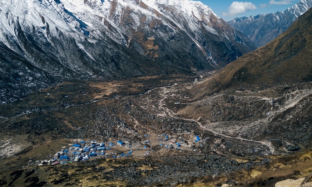

The ground had barely stopped shaking when the sound arrived not a rumble, survivors would later say, but something closer to an explosion, rolling down off the south face of Langtang Lirung. Colin Haley, an American climber near Kyanjin Gompa in the upper valley, turned to look and saw a cloud of white and grey climbing hundreds of meters into the sky, tearing downhill toward him.
He ran for a meadow. It caught him anyway, blasting him thirty to forty meters through the air before he slid to a stop lower on the slope. In that instant, he thought, this is the avalanche I die in.
Lower in the valley, in Langtang village itself, there was barely time to react. Guides screamed for people to run, though there was nowhere to run to. A towering plume of pulverized snow, ice and rock rolled over the settlement witnesses would compare it to news footage of Mount St. Helens erupting and then came the wind, a hurricane-force blast that flattened whatever the debris didn’t already bury. When the air cleared, a village of several hundred people, its guesthouses full of spring trekkers, had simply stopped existing.
A local man, Phinjo Tamang, made his way to where his community had stood and found nothing. “Everyone is dead,” he said.
It took less than two minutes. By the time the dust began to settle over the Langtang Khola, one of Nepal’s most storied trekking valleys had become the site of the single worst concentration of death in a disaster that would kill thousands across the country.
A Mountain Comes Down
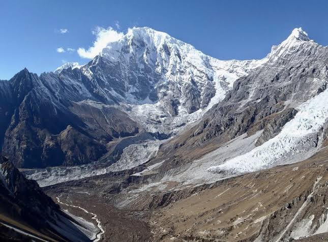
The trigger was the magnitude 7.8 Gorkha earthquake, which struck at 11:56 a.m. on April 25, 2015. Within seconds to a couple of minutes, the shaking dislodged hanging glaciers and thick snow and ice sitting on the south face of Langtang Lirung the 7,227-meter peak that towers over the valley along with slopes on nearby Langtang II.
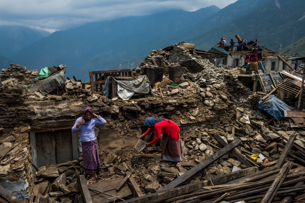
Daniel Berehulak for The New York Times
The failures began from several points high on the mountain, above roughly 6,000 to 7,000 meters.
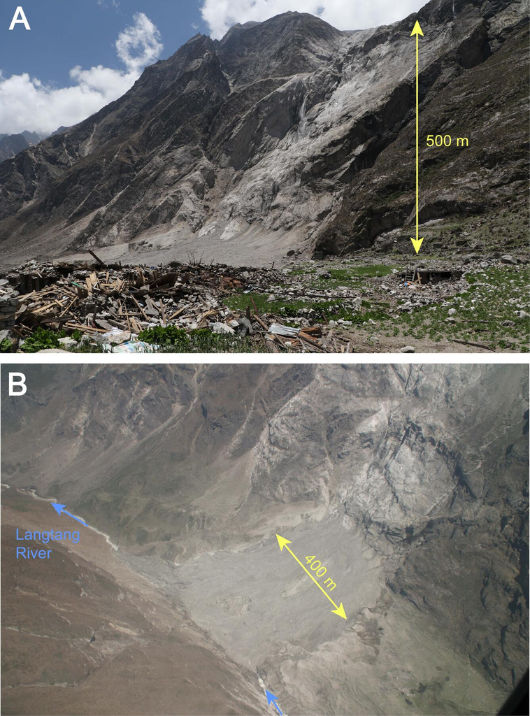
As the mass fell, it picked up more snow, ice, rock and loose debris, becoming a fast-moving river of material that went partly airborne as it shot over a steep cliff, then slammed into the valley floor at about 3,400 to 3,500 meters elevation essentially at village height. Scientists estimate the moving mass at somewhere between 6.8 and 14 million cubic meters of mixed snow, ice and rock; some popular accounts have put the weight at roughly 40 million tons.
Whatever the precise figure, it was enough to generate winds that reached, by some estimates, well over 300 kilometers an hour, flattening buildings and trees far from where the debris itself came to rest. The wave of material ran up the opposite slope some 200 meters, and the destruction stretched more than a kilometer along the valley floor. Popular descriptions have likened the energy released to several kilotons of TNT.
Langtang village home to somewhere between fifty and a hundred households, or 300 to 400-plus permanent residents, swollen that week with trekkers filling its lodges was almost completely wiped out. Only a handful of structures, sheltered by outcrops of rock, survived in some accounts. Nearby hamlets, including Thyangshyap, Mundu and Singdum, were also badly damaged by debris, the air blast, or rockfalls that followed in the following days. Across the opposite hillside, whole stands of forest were knocked flat.
Death toll estimates for the valley range from roughly 175 to more than 300 — commonly cited figures put local Nepali deaths in the 176 to 243 range, alongside about 80 foreign trekkers and climbers, plus soldiers and others caught in the disaster.
More than a hundred bodies were never recovered. This happened against the backdrop of an earthquake that killed close to nine thousand people across Nepal, but it was Langtang, more than anywhere else, that became known as the single worst site of the catastrophe.
One overlooked factor made it worse. The winter before the earthquake had brought unusually heavy snow – four major storms between October 2014 and April 2015 left one to two meters of snow at high elevation, an accumulation researchers describe as a once-in-a-century event. That extra load of snow and ice sitting on the mountain’s upper slopes is part of why the avalanche, once triggered, carried so much material and produced such a powerful blast of air ahead of it.
How It Happened
Strip away the numbers and the sequence is simple to follow. The earthquake shook the mountain — not violently by Langtang’s local standards, but enough. That shaking was the final push needed to break loose snowpack and glacier ice that was already sitting on slopes steep enough, in places over 35 degrees, to fail.
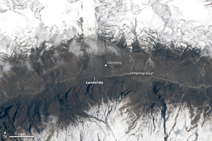
Once moving, the mass didn’t stay put: it gathered more material as it went, the way a snowball gathers snow, until it launched off a cliff edge and became briefly airborne before crashing onto the valley floor. The initial pulse was mostly snow and ice, driving a wall of wind and a muddy flow ahead of the debris itself.
Aftershocks in the following days and weeks, especially a significant one on May 7 to 10, triggered further rockfall that buried the deposit under an additional layer of stone.
The Langtang River itself was temporarily dammed by the debris, which could have created a second disaster if it had burst suddenly. Instead, it drained gradually through a tunnel that formed in the ice, sparing the valley a major flood on top of everything else.
What Survivors Remember
Ask people who lived through it, foreign or Nepali, and the accounts converge on the same handful of seconds: the ground moving, a roar or explosion, a cloud rising and racing downhill, then sudden darkness, wind, and either burial or being thrown.
Kat Heldman, a trekker near the village, remembers a “giant plume of white and gray” that reminded her instantly of volcanic footage. Guides around her were shouting “Avalanche, run!” advice that, as she put it afterward, missed the point: “You can’t outrun an avalanche.” People dove behind walls and were showered with snow and flying debris, some knocked flat by the force of it.
Phinjo Tamang, a local resident, heard the same thunder, felt the same shaking, and watched enormous pieces of ice break away from the mountain before what looked like smoke filled the air.
When he made it to the site of the village, there was nothing left to recognize. He spent the following hours digging at one point pulling a German trekker out of the ice while searching for his own family among the wreckage.
Other accounts describe a black, swirling cloud of rock, sand, ice and snow; hair whipped horizontal and frozen stiff in the wind; people clawing their own way out from under snow and debris; entire families lost within seconds. Survivors emerged bloodied, covered in mud and ice, with head wounds, broken bones and fractured backs.
For many, the ordeal did not end when the avalanche stopped moving. Survivors spent the first nights outdoors, in caves or under rock overhangs, with aftershocks still rattling the valley and rockfall still coming down, and little in the way of food, water or medical care. What people describe from those days, local and foreign alike, is less a single moment of fear than a kind of prolonged, disorienting shock — the sense of a life interrupted in an instant, with no clear sense of what came next.
Cut Off, and the Wait for Help
Langtang was, in the days after the avalanche, essentially unreachable by land — landslides, avalanche debris and destroyed trails sealed it off from the rest of Nepal.
The first word to reach the outside world came through satellite phones carried by foreign trekkers. It took roughly two days, until around April 27 or 28, for the first private helicopters to arrive.
Those first flights created their own crisis. Priority often went to insured foreign trekkers or those who could pay, and tensions boiled over between them and injured locals competing for the same limited seats.
At least one confrontation saw villagers physically block a helicopter from leaving until injured Nepalis including a toddler with two broken legs — were loaded aboard. Rocks and sticks reportedly changed hands in the chaos, and in a related incident a villager was killed by a helicopter’s tail rotor.
The Nepal Army eventually took control of the airlift, shifting the operation to a need-based system that evacuated the injured first, regardless of nationality. Army Mi-17 helicopters worked alongside private and international aircraft over the following days, and roughly 300 people were flown out of the valley in total. The injured went to hospitals in Kathmandu; many other survivors were sheltered, at least initially, at a monastery known as Yellow Gumba. Search teams kept working through the unstable debris for days and weeks afterward, looking for bodies that, in many cases, would never be found.
Two Faces, One Mountain
Langtang Lirung has, in other words, already shown what it is capable of. It is worth noting, briefly, that in August 2026 — eleven years after the avalanche a separate hazard event originated on the north side of the same massif, sending debris into the Lhende Khola drainage that feeds the Bhote Koshi River near the Nepal-China border, and on downstream toward the Trishuli.
That site sits only a short distance from Langtang village as the crow flies, but on the opposite flank of the mountain, feeding an entirely different river system a transboundary border corridor rather than an enclosed high valley. The two events are not the same story, but they share a source — a mountain whose steep, glacier-covered faces remain genuinely unstable on more than one side.
With that noted, the story of 2015 is the one that unfolded inside this valley, and it is to that story — the return — that the valley’s recent history really belongs.
Coming Back
The people evacuated from Langtang in the spring of 2015 scattered to Kathmandu and to temporary camps, and for a while, many simply stayed away.
That was understandable: homes were gone, family members were gone, and the site of the village itself was buried under debris. But over the years that followed, a core group of Langtangpa the valley’s own people made the decision to return.
They did not rebuild on the same ground. The original village remains largely under the avalanche deposit to this day, a stretch of rubble that trekkers still walk across on the trail. Instead, survivors established a new settlement nearby, on ground judged safer, using construction methods stronger concrete, better foundations designed to withstand another earthquake, blended with traditional building styles.
Further up the valley, Kyanjin Gompa, which had suffered comparatively less damage, grew rapidly and became the new center of gravity for the valley’s tourism economy, busy enough that some now half-jokingly call it “Thamel on the mountain,” after Kathmandu’s tourist district. Monasteries, a school, the valley’s historic yak-cheese factory, trails and bridges were rebuilt or repaired, with labor and funding from local residents, international aid groups and relief donations.
The main trekking trail reopened around 2017. By the mid-2020s, the valley had, in some ways, moved past simple restoration into new growth: more lodges and guesthouses than existed before 2015, improved stone stairways on the trail, and modern conveniences like WiFi that weren’t there before the disaster.
A stone memorial, stacked with Buddhist mantras, now marks what happened. Yaks graze again, prayer flags fly, and rhododendron forests have filled back in along the trail. The resident population is smaller than it was before the earthquake by some accounts, fewer than half of the original families returned to stay permanently but the valley’s capacity to host visitors is larger than ever.
Not everyone stayed, and not everything came back the way it was. Some younger residents moved to Kathmandu or abroad rather than rebuild. Yak herding, once a mainstay of the valley’s economy, has declined, with fewer herders and less cheese production as the work has become harder to sustain. The families who did return say they came back for reasons beyond simple economics a livelihood tied to tourism and herding, a religious and cultural attachment to the valley as a beyul, or hidden sacred land in Tibetan Buddhist tradition, and a wish to rebuild something for the next generation rather than let the place disappear. Some of the first to reconstruct, in fact, were lodge owners who had lost family members in the disaster.
Why People Still Go
Visitor numbers collapsed to almost nothing in 2015, then began climbing once the trail reopened in 2017, a recovery interrupted for a couple of years by the COVID-19 pandemic before resuming.
In recent full years, Langtang National Park has recorded somewhere in the range of 24,000 to 37,000-plus total visitors, a mix of Nepali, regional and international trekkers, with the busiest seasons falling in spring and autumn.
Lodge capacity has grown even faster than visitor numbers studies point to roughly 74 percent more guesthouses in the rebuilt Langtang village area, and more than 150 percent more in Kyanjin Gompa, compared with before the earthquake. Nearly every building in the new village now doubles as a place for trekkers to sleep.
The draw itself hasn’t changed much. Langtang remains the closest major Himalayan trek to Kathmandu — a road journey of seven to nine hours to the trailhead at Syabrubesi, no flight required and a shorter, generally gentler trek than Everest Base Camp or the Annapurna Circuit, typically six to ten days round trip.
The scenery is the same dramatic backdrop of ice and rock that drew climbers and trekkers here in the first place: close-up views of Langtang Lirung and its glaciers, alpine meadows, rhododendron forest, and viewpoints like Kyanjin Ri and Tserko Ri for sunrise over the peaks. The valley’s Tamang and Tibetan Buddhist communities, with their monasteries, prayer flags and mani walls, give it a cultural texture that feels less shaped by mass tourism than some of Nepal’s more famous routes.
Langtang National Park Nepal’s first Himalayan park adds red pandas, Himalayan tahr and, for the fortunate, a chance at a snow leopard sighting, along with the nearby sacred lake of Gosaikunda, itself a major pilgrimage destination.
And for some visitors, there is something else drawing them now: the story of the place itself, a valley that was all but erased and came back. As of the most recent reporting through 2025 and into 2026, the upper Langtang Valley has been functioning as a normal trekking destination.
The 2026 flash flood, when it came, struck the separate Bhote Koshi and Rasuwagadhi-Syabrubesi road corridor that serves as the valley’s gateway disrupting access for a time rather than the Langtang Khola valley floor or the rebuilt villages themselves.
The Shadow It Leaves
Langtang Lirung is, by any honest measure, both one of the most beautiful mountains in Nepal and one of the most dangerous.
The 2015 avalanche remains the defining catastrophe of this particular valley the event against which everything since is measured. What happened on the mountain’s opposite flank in 2026 is a separate story, but it is also a reminder, plain and simple, that the same steep, ice-covered faces that produced one disaster can still threaten different communities and different corridors on another side of the mountain.
None of that changes what has actually happened in the valley itself over the past decade. People came back.
They rebuilt, not on the old foundations but nearby, on ground they judged safer, and they built for the future rather than simply restoring the past. Trekkers walk the same trail today past prayer flags and grazing yaks, past a stone memorial stacked with mantras, and across a stretch of rubble that used to be a village. The mountain has not become any less dangerous. But the valley, in the plainest sense, is inhabited again which may be the closest thing to an ending this particular story has.
